Hiking and Nature Photography
"H" is for Hiking!
It pays to enjoy hiking if you are a nature photographer because your feet will get you to a lot more interesting locations than your car. Plus, you get to slow down and enjoy the outdoors while you are trekking to your favorite photo spot. I didn't really start hiking until I got more interested in nature photography, but I've grown to love it over the years - even the tough hikes. It really makes me appreciate how lucky I am to live in California, a state that offers over 5,000 hiking trails. Photography has lead me on hikes to the coast, mountains, desert, to wildflowers, and fall colors.
So - if you like to hike - or you just want to check out some photos from places you can hike to, you have come to the right spot. Here are some locations that I could not have reached without a little foot work. I've included details with each in case you are interested in hiking to these locations as well.
If you just want to look through the photos, or see more photos from hikes I did this year, then check out the Hiking Photo Gallery.
|
Location: Black Point Fissures, Mono County, California |
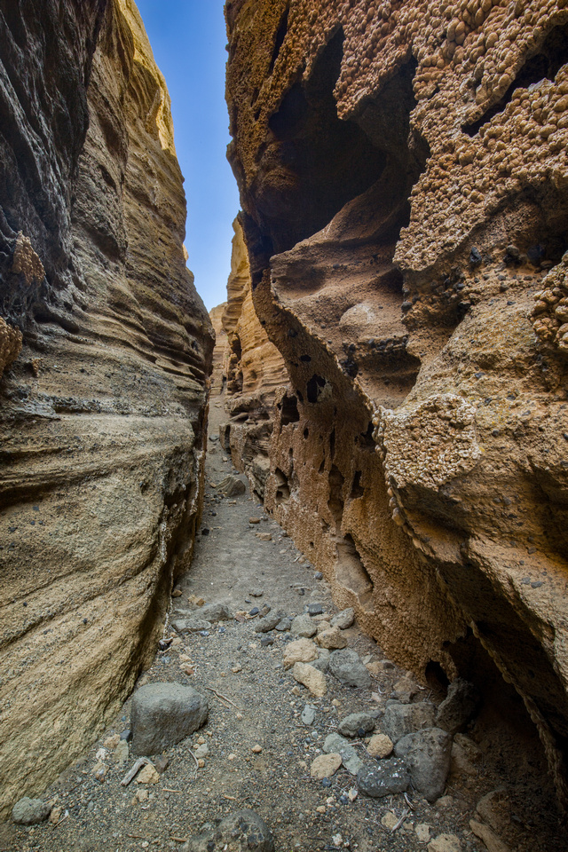 Black Point Fissures, MonoA short, but fun slot canyon on the north side of Mono Lake. Black Point Fissures, MonoA short, but fun slot canyon on the north side of Mono Lake.
|
|
Hike distance (round trip): 1.8 miles |
|
|
Hike difficultly (1-5): 2 |
|
|
Hike description: There is no trail to this small slot canyon, but it is short and would be difficult to get really lost. It is exposed, so if you are hiking in the summer months, bring sunscreen and plenty of water. Also, the sage brush can scratch up your legs so pants are a good choice too. |
|
|
Considerations/Notes: Reaching the parking lot requires driving on an unpaved road for roughly 3 miles but a regular car can make it. |
| Location: The Wave, Coyote Buttes Wilderness, Arizona |
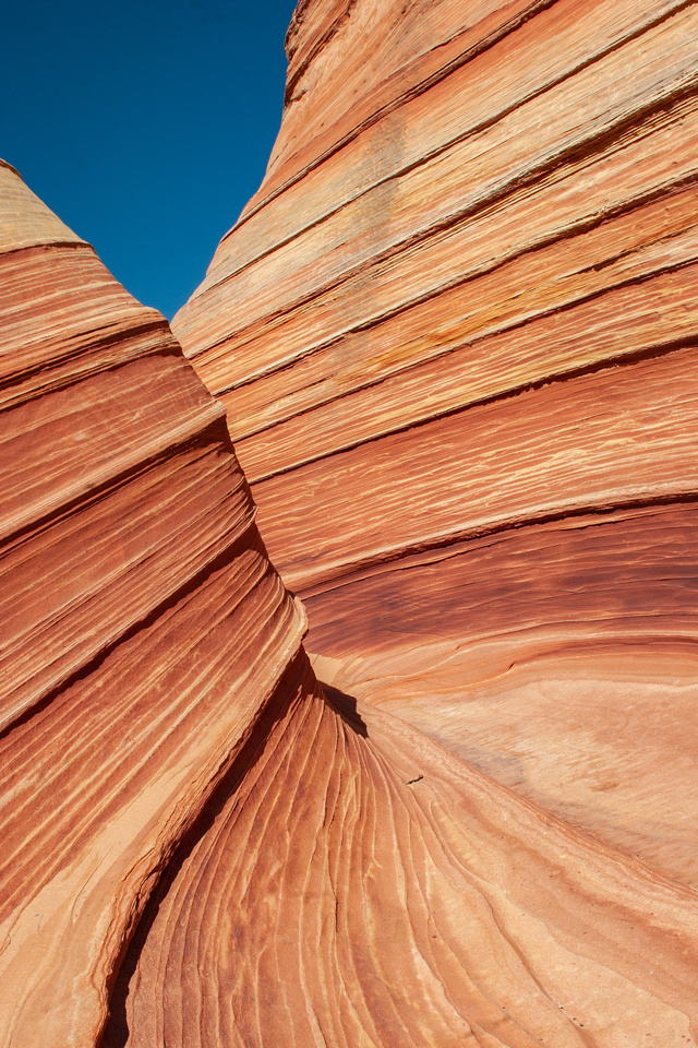 The Wave, Coyote Buttes, ArizonaThe Wave hike is quite famous and coveted. They only issue 20 permits per day, 10 in advance via an online lottery and 10 same day via an in person lottery. When I hiked this, I was fortunate to get the last permit for that day. In 2017 over 160,000 people registered for the permit lottery, meaning less than 5% of people who tried actually got to hike it. The Wave, Coyote Buttes, ArizonaThe Wave hike is quite famous and coveted. They only issue 20 permits per day, 10 in advance via an online lottery and 10 same day via an in person lottery. When I hiked this, I was fortunate to get the last permit for that day. In 2017 over 160,000 people registered for the permit lottery, meaning less than 5% of people who tried actually got to hike it.
|
| Hike distance (round trip): 6.3 miles | |
| Hike difficultly (1-5): 2-3 | |
| Hike description: there is no marked trail to reach these unique rock formations. You begin your hike in a wash for about a half a mile before hiking up towards the top of a ridge. From here, there are a landmarks to help you stay on track. You are rewarded with fantastic red-orange rock formations unlike anywhere else. | |
| Considerations/Notes: This hike requires a permit, which is by lottery. They only issue 20 permits per day and the BLM will fine you if you enter the area without one. Needless to say, there is lots of competition for permits, but it is worth it! |
| Location: Lake Aloha, desolation wilderness near Echo Lake, California |
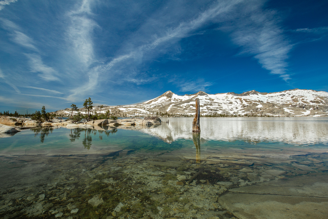 Lake Aloha, Tahoe BasinLake Aloha. A very popular backpacking location. When I arrived, I started walking along the shore to get some photos and I didn't realize that one of the backpackers was going to the bathroom within 10 feet of me. Kind of awkward. . .If that hiker was you - you aren't supposed to be peeing that close to the lake. :) Lake Aloha, Tahoe BasinLake Aloha. A very popular backpacking location. When I arrived, I started walking along the shore to get some photos and I didn't realize that one of the backpackers was going to the bathroom within 10 feet of me. Kind of awkward. . .If that hiker was you - you aren't supposed to be peeing that close to the lake. :)
|
| Hike distance (round trip): 13 miles | |
| Hike difficultly (1-5): 4 | |
| Hike description: The hike to Lake Aloha begins at lower Echo Lake. The trail is well marked, making it difficult to get lost. The surface is mostly dirt, but there are some rocky sections that can do a number on your ankles. Hiking poles are recommended. This is a popular location for backpacking as well. | |
| Considerations/Notes: Parking spots fill up fast, so prepare for a pre-hike to get to the trail head if you arrive after 7:30, especially during peak summer months. |
| Location: Loch Leven Lakes, Norden, California |
 MIddle Loch Leven LakeA wider view of Middle Loch Leven Lake. A nice spot to stop and have lunch. MIddle Loch Leven LakeA wider view of Middle Loch Leven Lake. A nice spot to stop and have lunch.
|
| Hike distance (round trip): 8.8 miles | |
| Hike difficultly (1-5): 3 | |
| Hike description: The trail head is easily reached off Highway 80 on Hampshire Rocks Road. There are 3 lakes at the top and all are great locations to stop and enjoy some snacks and a bit of nature before heading back to the rat race. This is also a popular location for backpackers and the lakes are warm enough for swimming in the summer. | |
| Considerations/Notes: The trail can be a bit difficult to follow in some places, but there are cairns to help mark the way. After you cross the railroad tracks, it's well marked. This trail will be covered in snow during the winter months and (I can attest) you will be hiking through a small stream during spring. Rocky trail in sections. Hiking poles are recommended. |
| Location: Barker Dam, Joshua Tree National Park, near Twentynine Palms, California |
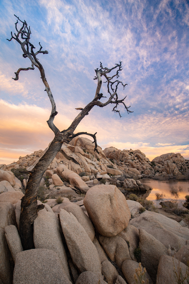 Barker Dam, Joshua Tree National ParkBarker Dam at sunrise. This spot is pretty magical when there is water in the lake and the clouds cooperate. Barker Dam, Joshua Tree National ParkBarker Dam at sunrise. This spot is pretty magical when there is water in the lake and the clouds cooperate.
|
| Hike distance (round trip): 1.3 miles | |
| Hike difficultly (1-5): 1 | |
| Hike description: Extremely well marked, easy loop hike. Sunrise can be quite beautiful here with the added bonus of having the place to yourself. | |
| Considerations/Notes: The small lake relies only on rainfall so drier months can result in a dry lake bed. |
| Location: Bear Gulch Reservoir, PInnacles National Park, California |
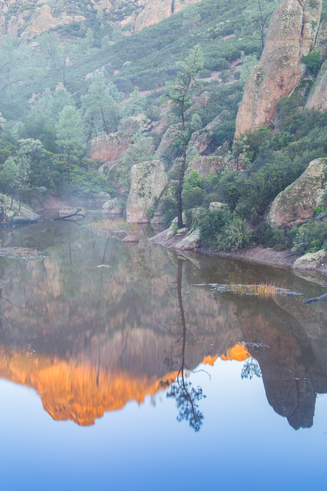 Bear Gulch Reservoir, Pinnacles National ParkBear Gulch at sunrise, with mist rising from the water and the sun lighting up the peak behind it. Bear Gulch Reservoir, Pinnacles National ParkBear Gulch at sunrise, with mist rising from the water and the sun lighting up the peak behind it.
|
| Hike distance (round trip): 2.2 miles | |
| Hike difficultly (1-5): 2 | |
| Hike description: this trail is well marked and follows a gentle incline with a lot of trees and interesting rock formations, where climbers can often be seen. You have an option of doing this as a loop, taking the Bear Gulch Cave route one direction and the regular trail the opposite direction. I recommend the cave route if it is open but bring a headlamp because it is totally dark. | |
| Considerations/Notes: the Bear Gulch Cave is closed during certain times of the year to protect the colony of bats that live there. Check the National Park website status before you go if you are interested in including the cave in your route. |
| Location: Trillium Falls, Redwoods National Park, California |
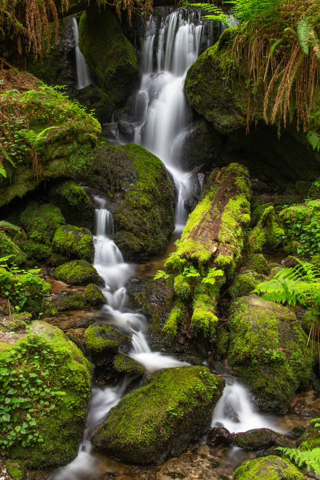 Trillium Falls, Redwoods National ParkThis is an easy hike that was virtually empty the day I hiked it. It is another one of those trails that has a Jurassic Park feeling to it. Trillium Falls, Redwoods National ParkThis is an easy hike that was virtually empty the day I hiked it. It is another one of those trails that has a Jurassic Park feeling to it.
|
| Hike distance (round trip): 2 miles | |
| Hike difficultly (1-5): 1 | |
| Hike description: This is an easily navigated trail through old growth redwoods and ferns, ending at a lovely moss covered waterfall. | |
| Considerations/Notes: It is not uncommon to see Roosevelt Elk near the parking area of the trail head! |
| Location: Bumpass Hell, Lassen National Park |
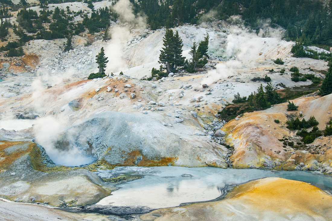 Bumpass Hell, Lassen National ParkThe geological events here create turquoise ponds and orange soil. Bumpass Hell, Lassen National ParkThe geological events here create turquoise ponds and orange soil.
|
| Hike distance (round trip): 3 | |
| Hike difficultly (1-5): 2 | |
| Hike description: This geothermal area is one of the neatest features at Lassen. It's like visiting a mini Yellowstone, only with a fraction of the drive. The trail is slightly uphill on the way in, then drops somewhat steeply as you approach the basin. You can view it from above without making the descent too. | |
| Considerations/Notes: This area is geothermal and gives off sulphur gasses which can offend those with sensitive noses. It's not that bad really. |
| Location: Golden Canyon, Death Valley National Park, California |
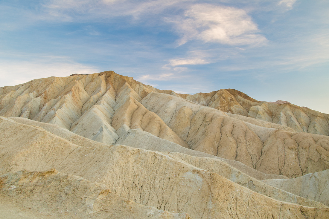 Golden Canyon, Death Valley National ParkGolden Canyon actually has a few different hiking loops that you can do, and I've only done 1 so far! This hike takes you up to the base of Zabriskie Point, which is a popular location to watch the sunrise and sunset. This was just before sunset. Golden Canyon, Death Valley National ParkGolden Canyon actually has a few different hiking loops that you can do, and I've only done 1 so far! This hike takes you up to the base of Zabriskie Point, which is a popular location to watch the sunrise and sunset. This was just before sunset.
|
| Hike distance (round trip): 3 miles | |
| Hike difficultly (1-5): 2 | |
| Hike description: The trail follows a wide and rocky canyon gradually uphill as it makes its way towards a rock formation called the Red Cathedral. This can be combined with other trails at Zabriskie Point to make a longer loop hike as well. | |
| Considerations/Notes: Death Valley can be warm even in the winter months so be prepared with sunscreen and water. |
| Location: Proxy Falls, Willamette National Forest, Oregon |
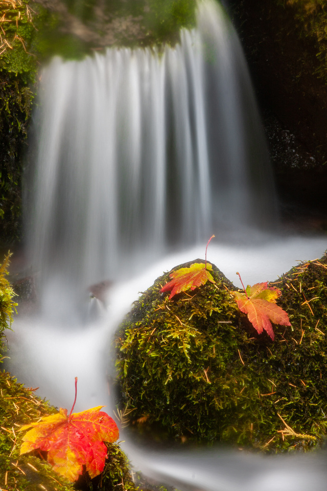 Proxy Falls, Willamette National Forest, OregonThis is a smaller cascade coming off of Proxy Falls with some maple leaves showing their autumn color. Proxy Falls, Willamette National Forest, OregonThis is a smaller cascade coming off of Proxy Falls with some maple leaves showing their autumn color.
|
| Hike distance (round trip): 1.6 miles | |
| Hike difficultly (1-5): 1 | |
| Hike description: The trail is easy and well marked, making for a nice stroll. During autumn, you will see maples in blazing orange and yellow. | |
| Considerations/Notes: If the gate to the trail head is closed, you need to add an additional 2 miles each way to the trip. |
| Location: Indian Arch, Yosemite National Park, California |
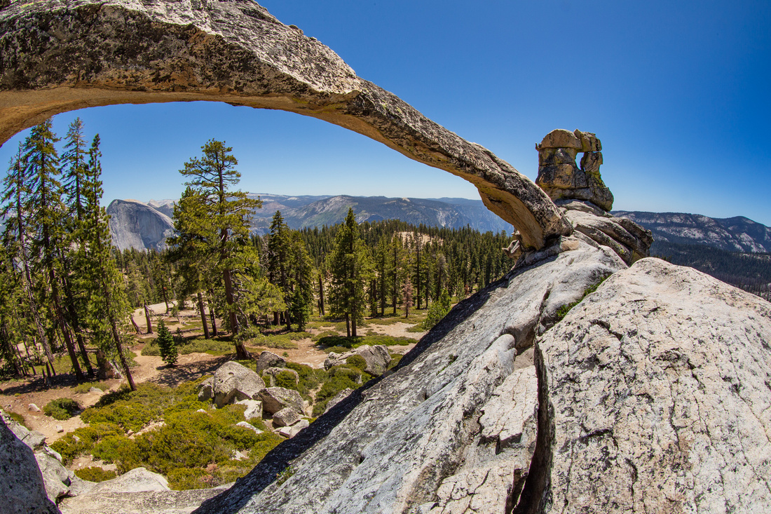 Indian Arch, Yosemite National ParkDid you know that Yosemite only has one natural stone arch in the entire park? This is it, and you can find it on the way to North Dome. I have seen pictures of people on top of the arch, which is scary because it is high up, narrow, and delicate. I had to squeeze myself under it with a fish eye lens and I still didn't capture the whole thing. Indian Arch, Yosemite National ParkDid you know that Yosemite only has one natural stone arch in the entire park? This is it, and you can find it on the way to North Dome. I have seen pictures of people on top of the arch, which is scary because it is high up, narrow, and delicate. I had to squeeze myself under it with a fish eye lens and I still didn't capture the whole thing.
|
| Hike distance (round trip): 7 miles | |
| Hike difficultly (1-5): 3 | |
| Hike description: The hike begins at the Porcupine Creek trailhead on Tioga Pass. The trail is well marked but there are a couple of stream crossings along the way. If you hike just another 0.6 miles further, you will reach North Dome with spectacular views of Half Dome and Clouds Rest. | |
| Considerations/Notes: Reaching the top of the arch requires some rock scrambling, and I recommend going up the back as opposed to the front. It's easier to navigate and a bit safer. |
| Location: Cinder Cone, Lassen National Park, California |
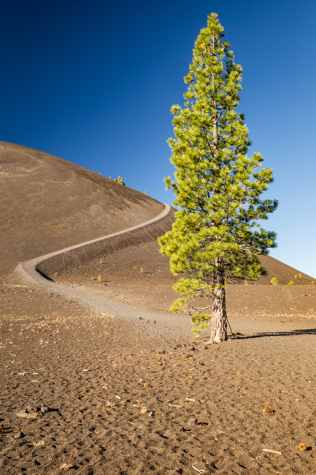 Cinder Cone trail, Lassen National ParkThis is a shot of the beginning of the climb up the cinder cone. Cinder Cone trail, Lassen National ParkThis is a shot of the beginning of the climb up the cinder cone.
|
| Hike distance (round trip): 4 miles | |
| Hike difficultly (1-5): 4 | |
| Hike description: This hike starts at the Butte Lake section of Lassen, which is in a remote section of the park. The trail starts out innocently enough but once you reach the section that ascends the cinder cone, you are basically hauling yourself up a steep pile of loose volcanic rock, for what feels like an eternity. The views are worth it though, especially seeing the fantastic lava beds at sunrise. | |
| Considerations/Notes: I hiked this at sunset one night then sunrise the following morning. I thought sunrise was better but honestly, this is a great hike anytime. |
| Location: Table Mountain wildflowers, Oroville, California |
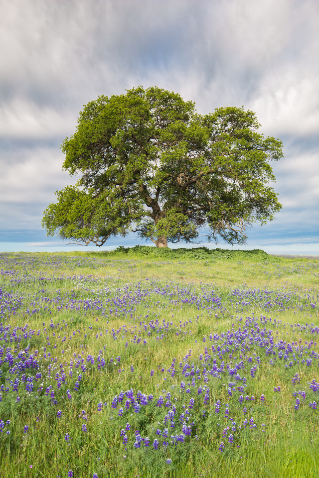 Oak and lupine, Table MountainThe trails at Table Mountain are often muddy and challenging to follow in the spring, but the fields of wildflowers cannot be beat. Oak and lupine, Table MountainThe trails at Table Mountain are often muddy and challenging to follow in the spring, but the fields of wildflowers cannot be beat.
|
| Hike distance (round trip): Varies 1-7 miles | |
| Hike difficultly (1-5): 1-2 | |
| Hike description: The trails here are not marked but if you go during wildflower season (Mar-Apr), it is hard to get lost because you will see a string of people flocking to and from the parking lot. | |
| Considerations/Notes: A "one day" or annual lands pass is required to access this site, which can be purchased at the California Department of Fish & Wildlife website for $5.00. |
| Location: Pipwai Trail, Road to Hana, Maui |
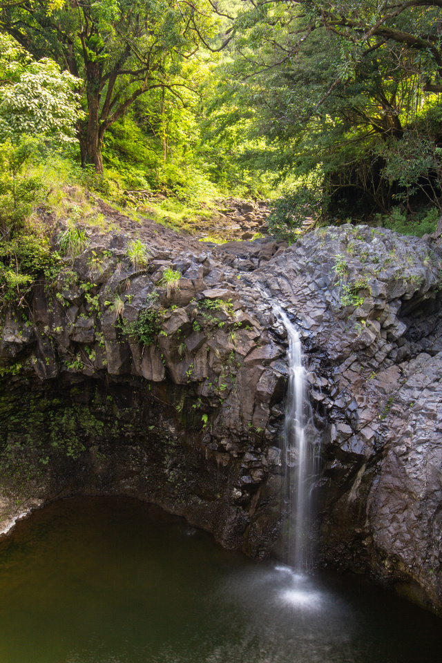 Pipwai Trail, MauiThis is a very scenic trail towards the end of the Road to Hana that leads to a much larger waterfall than the one in this photo, but I liked the composition of this one with the lava and rain forest. It's very "Hawaii". Pipwai Trail, MauiThis is a very scenic trail towards the end of the Road to Hana that leads to a much larger waterfall than the one in this photo, but I liked the composition of this one with the lava and rain forest. It's very "Hawaii".
|
| Hike distance (round trip): 3.4 miles | |
| Hike difficultly (1-5): 2 | |
| Hike description: This trail passes several waterfalls, a bamboo forest, and stream. It is well marked with pleasant surfaces to walk on. They even added a boardwalk to cross over the marshy section of the bamboo forest. How thoughtful. | |
| Considerations/Notes: There were a lot of mosquitos on this trail. We had bug spray and were fine but we encountered a group of hikers that did not and they had visible welts on their legs. We quickly handed them some bug spray so they could survive the rest of their hike. |
| Location: Four Mile, Panorama, & John Muir Trails, Yosemite National Park |
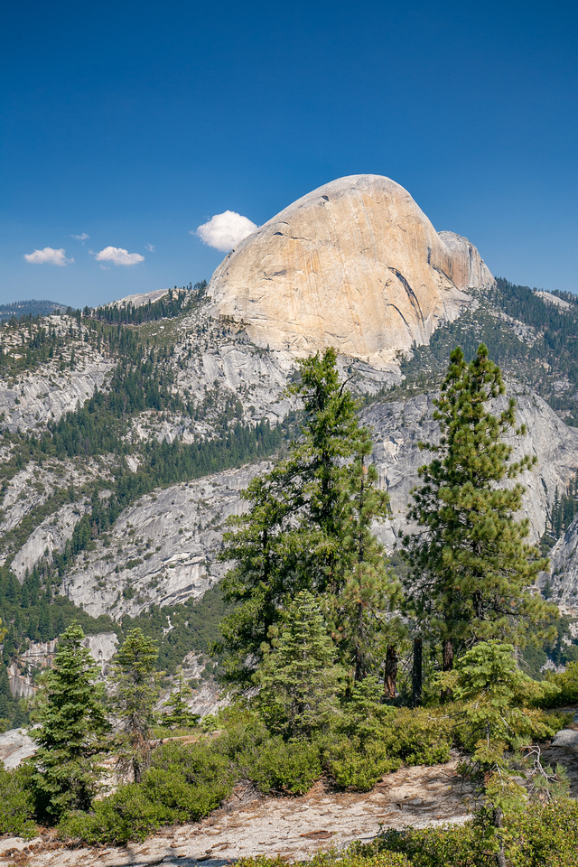 Half Dome from the John Muir TrailThis was taken along the John Muir Trail between Illilouette Falls and Nevada Falls. Half Dome from the John Muir TrailThis was taken along the John Muir Trail between Illilouette Falls and Nevada Falls.
|
| Hike distance (round trip): 16.5 miles | |
| Hike difficultly (1-5): 5 | |
| Hike description: I saved the best for last! This hike is known as one of the epic hikes in Yosemite. You start at the Four Mile trail head, and hike from the Valley floor up to Glacier Point, then connect to the Panorama Trail, hiking down to Illilouette Falls, then back up out of Illilouette Gorge, eventually connecting to the John Muir Trail. At the John Muir Trail connection, you can opt to take a short diversion over to Nevada Falls before you make your final descent via the John Muir switch backs. | |
|
Considerations/Notes: When the Yosemite shuttle is running, you can hop on at the end of the trail and ride it back to your car at the Four Mile trail head, saving you a 3 mile trek across the valley. The mileage here reflects the distance when the shuttles were not running. |
I've spent quite a bit time hiking in 2020. I believe I am up to 24 hikes this year as of this posting. Since I wasn't able to post all pictures here, I added some to the Hiking Photo Gallery in case you are interested in checking any of them out.
